DICCA MeteOcean Re-Analysis 1979-2018
The MeteOcean group at DICCA has performed a re-analysis of
atmospheric and wave conditions, producing an hindcast database
spanning from January 1979 till the end of December 2018 over the
domain employed for the atmospherical and wave condition simulations.
The hindcast dataset for wave characteristics can be employed for
Coastal and Ocean Engineering studies and researches. DICCA MeteOcean
group is willing to collaborate and share its knowledge for research
and consulting projects.
Meteorological re-analyses have been developed employing NCEP Climate
Forecast System Reanalysis, CFSR for the period from January 1979 to
December 2010 and CFSv2 for the period January 2011 to December 2018.
For some available application and service see the section below. For
any enquires please write to meteocean(at)dicca.unige.it
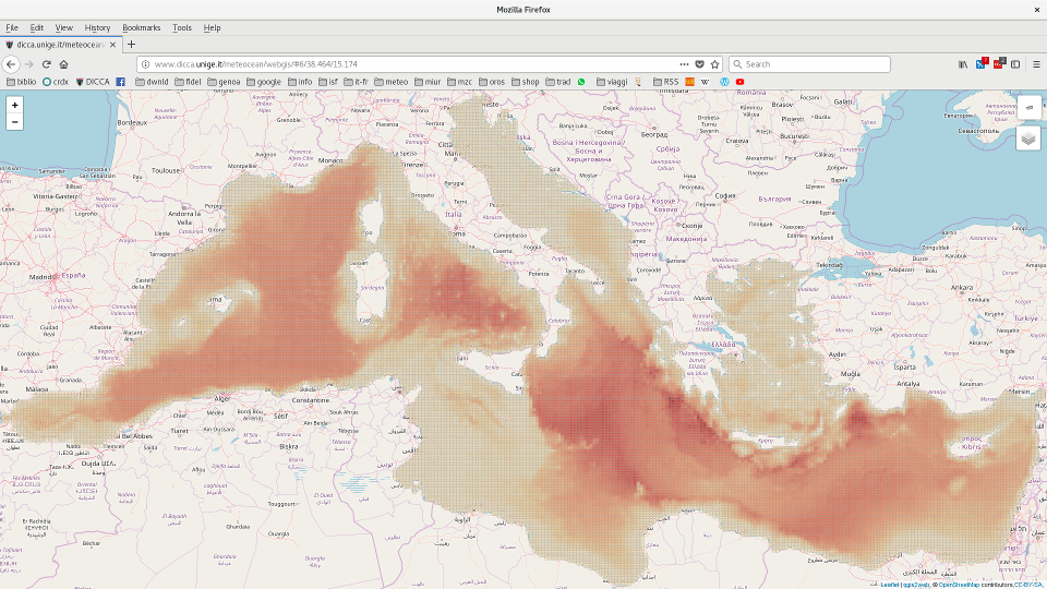
If you are interested in hindcast data please click to the following
map in order to identify grid points of interest
Parameters provided by the hindcast
Hindcast grid points are provided in multicolumn ASCII format. Every
column corresponds to a different physical parameter and every line is
referred to consecutive time steps (1 hour steps from 01/01/1979 till
31/12/2018). Parameters are stored as:
YYYY mm dd HH:MM:SS Hs Tm Tp Dirm Dirp Spread Lm Lp uw vw Hsws Tmws Dirws s1Hs s1Tm s1Dir s2Hs s2Tm s2Dir
YYYY - Year
mm - month
dd - day
HH - hour
MM - minutes
SS - seconds
Hs - Significant Wave Height [m]
Tm - Mean Period [s]
Tp - Peak Period [s]
Dirm - Mean Direction [°N]
Dirp - Peak Direction [°N]
Spread - Directional Spreading [°]
Lm - Mean Wavelength [m]
Lp - Peak Wavelength [m]
uw - West-East Wind Velocity [m/s]
vw - South-North Wind Velocity [m/s]
Hsws - Wind Waves Significant Height [m]
Tmws - Wind Waves Mean Period [s]
Dirws - Wind Waves Mean Direction [°N]
s1Hs - First Swell Wave Height [m]
s1Tm - First Swell Mean Period [s]
s1Dir - First Swell Mean Direction [°N]
s2Hs - Second Swell Wave Height [m]
s2Tm - Second Swell Mean Period [s]
s2Dir - Second Swell Mean Direction [°N]
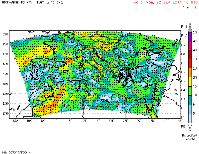
WRF simulation domain
The numerical models
The numerical model chain employed in this study consists in a
meteorological model for the reanalysis and simulation of winds and
atmospheric fields and a third generation model for the description of
generation and propagation of wind and swell waves in the
Mediterranean basin.
The wind model
The wind forcing employed in the simulations has been provided by the 10-m
wind fields obtained using the non-hydrostatic mesoscale model WRF-ARW
version 3.3.1 (Skamarock et al., 2008).
A single computational domain has been implemented for the WRF model,
covering the whole Mediterranean with a ~10 km resolution Lambert
conformal grid.
Initial and boundary conditions for the atmospheric simulations with
the WRF model were provided from the CFSR (Climate Forecast System
Reanalysis) database (Saha et al., 2010). Use of CFSR wind field
reanalysis for wave modeling proved to compare well with measurements
even though sometimes it is possible to miss the highest wave events
(e.g. Chawla et al., 2013; Cox et al., 2011; Splinder et al., 2011).
Simulations has been performed by means of 24-hr-long WRF simulations,
with outputs saved every hour, updating the analysis every 24 hours,
whereas the boundary conditions were imposed every three hours. This
kind of approach leads to unavoidable discontinuities in the wind
fields every 24 hours. However, we believe that this is a minor
drawback since the influence of such discontinuity on the wave field
is reasonably small due to the delayed response of wave growth and
development to the wind forcing.
On the other way, making a continuous WRF simulation would certainly
trigger signicant errors in the wind output, since longer term
forecasts progressively drift away from reality, compensating the
advantage of eliminating discontinuities.
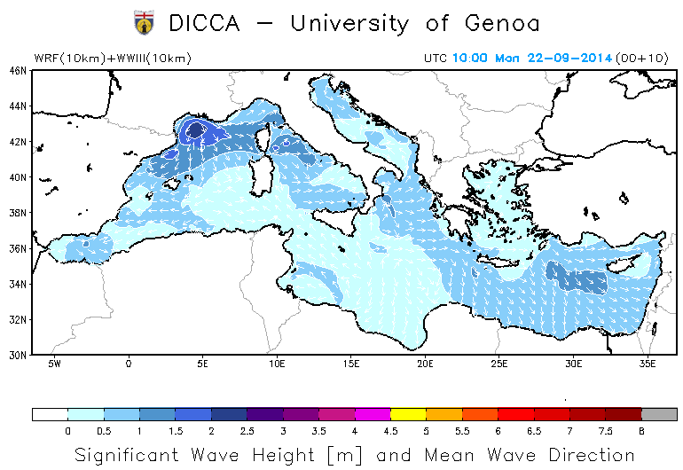
WavewatchIII simulation domain
The wave model
The re-analysis of wave conditions relies on the third generation wave
model WavewatchIII, version 3.14 (Komen et al., 1994; Tolman, 2009),
for the description of wave generation and evolution processes of the
wave field.
Following the set-up employed for wind simulations, WWIII has been
implemented in the Mediterranean basin on a regular grid (hereinafter
referred to as R10) with a resolution of 0.1273×0.09 degrees,
corresponding almost to 10 km at the latitude of 45°N, and ETOPO1
data has been used for the interpolation on the computational grid of
the bathymetry.
The model has been forced with the wind fields obtained from the
atmospheric model with an hourly time step.
Validation of the hindcast has been developed through the comparison
between the numerical results and wave buoy observations, employing
integrated parameters such as the significant wave
height
Hs, the mean wave period
Tm
and the mean propagation direction
θm (see Mentaschi
et al., 2013; Mentaschi et al., 2015).
Re-analysis simulations output are recorded hourly in all points of the
computation grid for both meterological and wave quantities.
Coastal and Ocean Engineering Applications
Hindcast dataset can be used in order to perform researches and
studies in the field of Coastal and Ocean Engineering. The
availability of an extended time serie with a good spatial resolution
allows in fact to have a detailed and reliable knowledge of wave
climate in any point of the numerical domain (i.e. inside the
Mediterranean Sea).
It is then possible to perfom all kind of analysis on the wave data
for Metocean Engineering purposes, ranging from offshore structure
design to coastal morphodynamics studies.
Available Products
-
Hindcast Time Series Files
Time series of waves and winds data
for the whole period covered by the hindcast dataset (1-hourly
time steps).
-
Extremes analysis
Return-period extremes of wind speed, wave
height and period derived for omni-directional and specific
sectors based on local wave/wind climatology.
-
Occurence Statistics
Operability data expressed as monthly or
annual frequency of occurrence tables of wind speed by wind direction,
wave height by wave period and direction, and exceedance and
non-exceedance duration statistics for wind speed and wave height.
Time series and all derivative products can be delivered in ASCII
format and final reports can be provided. For any enquire please
contact giovanni.besio (at) unige.it
Below we show some possible application developed by DICCA MeteOcean group.
Wave climate characterization
Extreme wave height values analysis
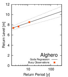
Extreme wave height analysis
for Alghero hindcast point
Extreme wave height analysis for
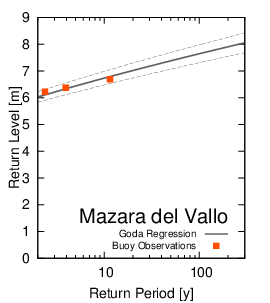
Mazara del Vallo hindcast point
The wave hindcast serie has been employed in order to perform an
evaluation of extreme values for significant wave height along the
Italian coast. A direct comparison has been performed between data
obtained by the re-analysis numerical simulation done by DICCA
MeteOcean group and the data provided by the network of buoys for
wave measurement along the italian coast (Rete Ondametrica Nazionale
RON).
Once the
comparison and validation has been performed on the RON historical
data, and the hindcast dataset has confirmed its reliability, an
extensive analysis for significant wave height and return periods
has been developed. This kind of analysis can be performed in any
chosen location inside the Mediterranean Sea giving an useful and
reliable analysis tool for Maritime and Coastal Engineers.
Wave climate assessment and characterization can be performed on the
same dataset, giving useful information for wave regimes
characterization for coastal processes and sediment transport
analysis.
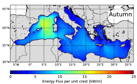
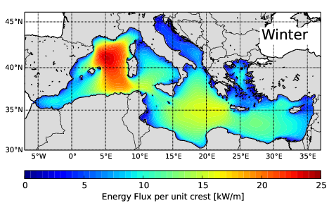
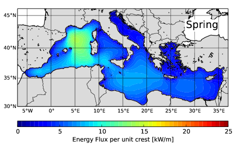
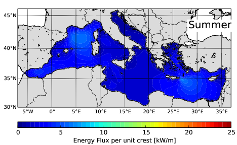
Wave energy assessment for renewable energy projects
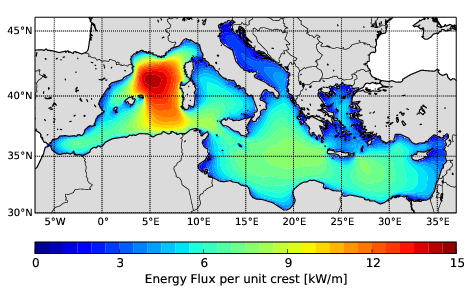
Annual Mean Wave Energy Flux 1979-2014
A detailed and reliable knowledge of wave energy resource in the
offshore region is of great importance to characterize and define
areas where it would be convenient and suitable the development of
wave energy harvesting, making profitable and suitable local site
project planning and design. The development of a wave hindcast
simulation for extended period (1979-2015) allows to give a detailed
insight about the wave energy resource available in the
Mediterranean basin, identifiying and characterizing the most
interesting area for energy exploitation. The evaluation is carried
out on the basis of a wave hindcast simulation covering the period
1979-2015 with ouput recorded on a hourly basis. With high
resolution in space (almost 10 km) and time (1h) it is possible to
perform detailed analysis of wave potential characteristics in the
whole Mediterranean basin, providing information on seasonal and
longer term variability necessary for reliable and optimal design of
wave energy extraction equipment.